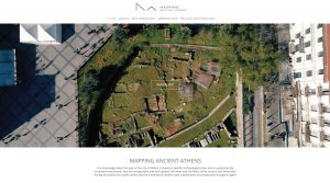
 Dipylon, Society for the Study of Ancient Topography, has promoted the execution of the ambitious Mapping Ancient Athens project, the results of which can be consulted openly on the Internet. It is a Database that collects, for the first time, 160 years of rescue archaeological excavations carried out in Athens, in an urban area of 6.7 km2, with data from 1,473 excavated sites, 670 plans and 1,400 bibliographical references. Thanks to Geographic Information Systems (GIS) and digital technology, it has been possible to create a digital map of Athens were, through different search engines, you can find the typology and chronology of the archaeological remains located in any of these 1,473 rescue excavations, essential to raise the urban and historical evolution of the city. Given its importance for the knowledge of ancient Athens, we have thought it convenient to present this news on our website, as well as congratulate the Greek institutions that have made this project possible.
Free access to Mapping Ancient Athens though tis link: https://mappingancientathens.org/en/home/
More news
Greek pottery from Mesas de Asta (Jerez de la Frontera, Cádiz)
Issue 59 (2025) of the Empúries journal of the Museu d’Arqueologia de Catalunya, which has just been published, contains the article “Greek pottery from Mesas de Asta (Jerez de la Frontera, Cádiz). New typological and chronological data and a contextualization of the consumption patterns” by Álvaro Miranda García and Antonio M. Sáez Romero, from...

Published Volume 9 of the Journal of Greek Archaeology
Volume 9 of the Journal of Greek Archaeology (JGA) was published in December 2024. This is a special edition, as it includes in addition to the traditional sections of the Serie, a first part containing the proceedings of the workshop held at the British School of Athens on March 30, 2023, on the use...
A set of Attic pottery from the Iberian necropolis of Alarcos III (Poblete, Ciudad Real) published
The article "Un depósito de ofrendas de cerámica ática y ungüentarios en la necrópolis ibérica de Alarcos III (Poblete, Ciudad Real)" has been published in the current issue of Archivo Español de Arqueología (AEspA 98 -2025-, 724. DOI: https://doi.org/10.3989/aespa.098.025.724) by Pedro Miguel-Naranjo, Miguel Ángel Rodríguez-Rabadán, Francisco Javier Morales Hervás, David Rodríguez González and M.ª...
Information about Dr. Xavier Aquilué (Iberia Graeca)
On September 6, Dr. Xavier Aquilué Abadías, scientific director of Iberia Graeca Centre at the Museu d’Arqueologia de Catalunya, retired after a long professional career in various public (Ajuntament de Badalona, Ajuntament de Tarragona, Diputació de Barcelona and Generalitat de Catalunya) and private (Col·legi Oficial d’Arquitectes de Catalunya) administrations. Dr. Aquilué expressed his gratitude...
Colección Museográfica de Cártama. Catálogo de la Colección Expositiva
Last December, the Consejería de Turismo, Cultura y Deporte de la Junta de Andalucía and the Ayuntamiento de Cártama (Málaga) published the book Colección Museográfica de Cártama. Catálogo de la Colección Expositiva, which includes an inventory of the 197 archaeological objects that make up the permanent exhibition of this collection managed by the Ayuntamiento...
Proconessian Marble Altar or Ablution basin discovered in El Turuñuelo
During the seventh archaeological excavation campaign carried out last June at the Tartessian site of Casas del Turuñuelo (Guareña, Badajoz, España), 27 fragments of a base and a fluted shaft of an architectural element of marble from the Greek island of Proconnese (Asia Minor) were found. The discovery dates from the destruction phase of...
Greeks in the Phoenician-Punic city of Baria (Villaricos, Almería)
On April 23, Nature journal published the article “Punic people were genetically diverse with almost no Levantine ancestors” which compiles the findings of a genetic (DNA) study of 210 individuals from 14 Phoenician-Punic necropolises in the central and Eastern Mediterranean (North Africa, Iberia, Sicily, Sardinia, and Ibiza). This ambitious project involved 64 international researchers,...
Reading Ancient Objects Inside Out. Greek Figure-Decorated Pottery in Portugal
In December 2024, the book Reading Ancient Objects Inside Out. Greek Figure-Decorated Pottery in Portugal was published in the Archaeopress Archaeology series. The scientific editors are Rui Morais, Delfim Leão, Maria de Fátima Silva, Daniela Ferreira, and David Wallace-Hare. The monograph examines Greek vases preserved in various museums and collections in Portugal through two...
Call for the Third Autumn International Research Bursary (l’Escala, 2025)
For the third consecutive year, the City Council of l’Escala (Alt Empordà, Girona) has announced the “Third Autumn International Research Bursary” for research in the social and natural sciences. The scholarship is awarded to the best project submitted whose theme subject of study is related to the landscape, natural environment, history, archaeology, anthropology, and...
The Greeks in Iberia and their Mediterranean context
Routledge has published the book The Greeks in Iberia and their Mediterranean context (New York, 2024), edited by Jens A. Krasilnikoff and Benedict Lowe, which collects the papers presented at the workshop held at Aarhus University (Denmark) on October 10 and 11, 2013, more than ten years ago, by different researchers of various nationalities....